Category Archives: Fire

Drought-Busting El Niño Getting Less Likely

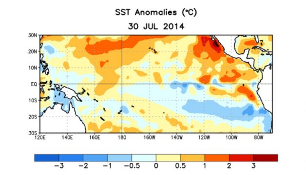
Average sea surface temperature (SST) anomalies (°C) for the week centered on 30 July 2014. Anomalies are computed with respect to the 1981 - 2010 base period weekly means. Photo: NOAA
Average sea surface temperature (SST) anomalies (°C) for the week centered on 30 July 2014. Anomalies are computed with respect to the 1981 – 2010 base period weekly means. Photo: NOAA

The idea of an El Niño rescuing California from its devastating drought appears to be nothing more than wishful fancy.

Not only have climate scientists recently downgraded the strength of a potential El Niño, but a report released Thursday by the U.S. Climate Prediction Center indicates that the odds of an El Niño happening this year at all are down.

An El Niño is the much-watched warming of the Pacific Ocean that tends to influence worldwide weather and has had many in California hoping it will trigger a wet winter for the rain-starved state.

While Thursday’s climate report suggests that an El Niño is still likely, the chances of seeing one this fall or winter dropped from 80 percent – projected in early reports – to 65 percent.

The change, said climate scientist Michelle L’Heureux, comes as the warmer-than-usual surface temperatures observed this spring in the equatorial Pacific have cooled.

The same underwater swell that pushed heat to the surface, known as a Kelvin Wave, is having its normal counter effect, but that effect has been much stronger than usual and has moved more cold water up than expected, L’Heureux explained.

“We’re still banking on seeing a reinvigoration of El Niño,” she noted. “But with that said, we wanted to lower our projections because there are structural weaknesses that have made this El Niño less likely.”

The federal forecast calls for the El Niño to be weak or moderate. The consensus earlier this year was that the event would be at least of moderate strength – and some believed it would be really strong.

In Northern California, strong El Niño’s have correlated with wet winters. San Francisco’s biggest rain year in the last century came during the big 1997-98 El Niño.

Weak and moderate El Niño’s, however, haven’t translated into significant rain years in Northern California. (Southern California has sometimes seen wetter weather during moderate and weak events.)

The absence of a strong El Niño doesn’t sentence Northern California to a dry winter.

More at SFGate.com >>>

Sacramento City Fire Considering Controlled Fires Along American River

Sacramento City Fire Department spokesman Roberto Padilla took Fox40’s Ben Deci on a tour of the American River Parkway. After an already intense fire season, he wanted to show us what is there, and what isn’t anymore.

“There’s acres upon acres and acres of this specific type of fuel load,” he said, gesturing to a bramble pile several feet high.

The tour took them through one sooty scorch-mark after another. They are monuments to a wildfire season that has been twice as tough here as it was last summer.

And now Padilla is putting forward an unheard of idea for the Parkway: the Fire Department starting some fires of its own.

 “It wouldn’t even be acres at a time you’re talking about. Just setting a 5′ x 30′ strip and burning that guy off and then doing another,” Padilla said.

He’s talking about controlled burns to get rid of some of the critically dry fuel that wildfire loves.

“An out-of-control controlled burn is another compelling argument,” said Stephen Green, President of the Save the American River Association. “It would happen. Absolutely.”

Green lives along the parkway. He’s convinced that, sooner or later, houses like his would be threatened by a controlled burn policy.

And he says there are other policies fueling this problem.

“This community has not done what it can do for those people camped on the Parkway. And they’re camped the entire length of the parkway,” he said.

In December 2011, Police were sent to break down tent cities in Center City Sacramento, and clear-out the the homeless people who lived in them. It is now clear where many went- deeper into the underbrush along the American River.

More at Fox40.com >>>

American River Parkway Fires Are Bigger And More Frequent

The American River Parkway is the crown jewel of Sacramento, a 23-mile stretch of forests, beaches, bike paths and hiking trails used by countless visitors each year.

It is also bone dry, and causing unprecedented headaches for area firefighters this year.

“We’ve had more multi-alarm fires in the last six months than we did in the last two years combined,” Sacramento Fire Department spokesman and firefighter Roberto Padilla said Friday.

Parkway advocates say firefighters have responded to 24 fires – 14 in the city jurisdiction alone – in the first half of the year, including blazes that have erupted from the unusually dry conditions caused by California’s historic drought.

“We’ve noticed a spike in grass fires … and the reason people are noticing is because in the past it would be a 2- or 3-acre fire and then we would get a hold of it,” Padilla said. “Now, you’re talking about 160 acres, like the Cal Expo fire (on July 4).

“The fire behavior is extremely explosive, and the concern for us is these are wildland-type fires in urban settings.”

There is nothing new about grass fires along the parkway. They happen every year – and most are started by humans, either accidentally or as arson. But this year, some area firefighters are particularly concerned about the potential for fires to burn larger and more quickly than in previous years.

So far this year, more than 200 parkway acres have burned, about the same amount that burned over the previous 18 months. With the peak of fire season coming in late August, the situation has left fire officials and parkway advocates debating what methods should be used to reduce the threat of fires, and whether a comprehensive plan should be drawn up to clear out underbrush before it ignites.

The immediate response by firefighters has been to knock down a blaze as rapidly as possible, because of the extreme conditions. Padilla said the Sacramento Fire Department is deploying four firefighters per engine rather than the typical three to make more force available to stop blazes, and the department is deploying additional resources much more quickly than in the past.

In the case of the Cal Expo fire, which burned up to the levee behind the state fairgrounds, the first firefighters dispatched called for additional help before they even arrived because of the size of the smoke column, Padilla said.

“We struck a second alarm before anyone even got there,” he said.

The causes of the fires are the same as in past years – almost invariably they’re caused by humans. The county estimates that the parkway is visited 5 million times a year by parkway users; other estimates put the figure as high as 8 million. With that many visitors, the potential for fire is high, and almost anything can spark a blaze – a campfire set by homeless people, a barbecue set up on an island by weekend visitors, a cigarette butt carelessly discarded.

“There’s just a lot of activity on the parkway,” Padilla said.

More at SacBee.com >>>

Read more here: http://www.sacbee.com/2014/07/19/6568312/american-river-parkway-fires-are.html#storylink=cpy
MMore
Read more here: http://www.sacbee.com/2014/07/19/6568312/american-river-parkway-fires-are.html#storylink=cpy

Fire Crews Contain Fast-Moving Parkway Blaze Along The American River Parkway

The Sacramento Fire Department responded to a five-acre fire along the American River Parkway around 2 a.m. Thursday.

Public information officer firefighter Roberto Padilla said the fire, along mile marker five of the parkway near Cal Expo and Bushy Lake, spread quickly due to relatively high wind speeds and thick vegetation. Though fast-moving, the two-alarm fire threatened no structures.

More at SacBee.com >>>

Suspect sought after fires set along American River in Sacramento

Sacramento Fire Department investigators are searching for a suspect who is believed to have started several small fires this afternoon along the American River near Highway 160.

Assistant Chief Kim Iannucci said the first crew responded about 2:40 p.m. to a fire on the north side of the river near Northgate Boulevard. Firefighters arriving at the scene reported fires on the south side of the river as well, and a second crew was dispatched to the area near Richards Boulevard, Iannucci said.

The fires were largely contained by about 4 p.m., although crews continued to mop up hot spots.

From the SacBee.com >>>

Prescribed Burns in Tahoe National Forest

The Tahoe National Forest American River Ranger District has begun its fall prescribed burn program. Fall and winter burning will include roadside hand piles, large machine piles, and up to 450 acres of underburning.

The exact timing of burns depends on specific fuel moisture and weather requirements designed to reduce the possibility of escape, manage smoke concerns, and ensure the best possible conditions for fuel consumption.

Burning is scheduled to occur in the following areas: Foresthill Divide; Humbug Ridge; the Sailor Point area off the Texas Hill Road; and Last Chance. Because smoke may cause diminished visibility during burning operations, forest visitors should stay alert for signs warning of prescribed burning or smoke obscuring the road. People traveling through a prescribed burn area should turn on headlights and be aware that burn personnel may be working along the road.

District fire managers work with the Redding Fire Weather Center and Placer County Air Pollution Control District to plan the prescribed burns to minimize smoke impacts to communities. However, some smoke may settle into the valleys during the evenings and mornings until atmospheric conditions allow for smoke dispersal.

For questions concerning the fall burn program, please contact fire management staff at the American River Ranger Station in Foresthill by calling (530) 367-2224. Daily updates can also be obtained at (530) 367-2224 as the burn program progresses.

For more Tahoe National Forest information, go to http://www.fs.usda.gov/main/tahoe/home.


Volunteers sought to repair trails damaged by American fire

Tahoe National Forest officials have reopened parts of two popular trails damaged in August by the American fire and are seeking volunteers to help rehabilitate the remaining trail segments.

The Western States Trail is open between Michigan Bluff and Deadwood Cemetery, and OHV Trail Loop 6, also known as Forest Service Trail 11E44, is open west of Deadwood Ridge Road.

The entire fire area, including all trails and roads within it, will remain closed for public safety until May 1, said Gwen Ernst-Ulrich, forest spokeswoman.

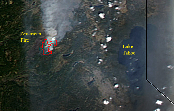
The fire, northeast of Foresthill in Placer County, burned 27,440 acres within the forest’s American River Ranger District and surrounding properties, including three historic buildings at the Pacific Slab mine.

Eighteen of the 25 miles of the Western States Trail damaged by the fire have been rehabilitated, Ernst-Ulrich said, and efforts are underway to winterize the remaining seven miles to minimize erosion.

Since 1974, the trail has been the site each June of the internationally known Western States 100-Mile Endurance Run from Squaw Valley to Auburn and, in August, the Tevis Cup Endurance Ride.

The remaining damaged seven-mile segment, between Last Chance and Deadwood, is listed on the National Register of Historic Places. It includes two fire-damaged bridges across the northern portion of the middle fork of the American River canyon.

“The (ranger) district is looking at alternate routes for these events if the swinging bridge that crosses the river is not able to be used in time,” Ernst-Ulrich said. “Thousands of other recreationists use this popular trail annually.”

More at SacBee.com >>>

Forest service officials assess trails in American Fire area

American_Fire

Now that fire activity within the American Fire area has diminished, Tahoe National Forest officials have assessed conditions on two popular trails: the Western States Trail and OHV Trail Loop 6, also known as Forest Service Trail 11E44 (Loop 6).

The Western States Trail between Michigan Bluff and Deadwood Cemetery is open, and Loop 6 is open west of Deadwood Ridge Road. The entire fire area, including all roads and trails, is closed under Forest Order 17-13-08, which is in effect until May 1, 2014.

Therefore, the Western States Trail and Loop 6 within the fire area east of Deadwood Ridge Road remain closed. These trails will be returned to acceptable standards before being considered safe for recreationists.

The American Fire affected approximately 25 miles of the trail. To date, roughly 18 of those miles have undergone rehabilitation through fire suppression and/or burned area emergency rehabilitation efforts.

More at TheUnion.com >>>

Roads to reopen today as American fire is put out

Mosquito Ridge Road near Foresthill will reopen to all traffic at 8 a.m. today.

A portion of the road has been closed for public and firefighter safety because of the American fire burning in Placer County northeast of Foresthill.

But, as firefighters reach containment of the fire, emergency vehicle traffic on the road has decreased, said Gwen Ernst-Ulrich, the forest’s acting public affairs officer, in a news release.

The fire, which started Aug. 10 and has burned 26,817 acres, was 99 percent contained as of Thursday night, officials reported. The cause is under investigation.

Three Forest Service roads, two popular trails and a campground within the fire area remain closed until further notice.

The roads include Deadwood Ridge Road from Foresthill Divide Road to the road’s end, Foresthill Divide Road from the intersection of Humbug Canyon Road to Robinson Flat and Flat Ravine Road from Robinson Flat Campground to Mosquito Ridge Road.

More at SacBee.com >>>


American Fire Pricetag Up To $12.5 Million

The bill for the 15,700-acre American Fire northeast of Foresthill reached $12.5 million Wednesday, with containment targeted for Sept. 1.

The fire is being described by fire officials as 63 percent contained, with firefighters watching the skies for thunderhead formations and possible lightning.

The fire has been determined to be human-caused, but Mike Johnson, information officer for the California Interagency Agency Management fire strategy team, said Wednesday that he can’t comment on the investigation or provide any additional information.

While Auburn was again free of smoke Wednesday, Colfax was suffering from a thick haze from the American Fire as atmospheric conditions changed.

On Wednesday, an army of 1,822 firefighters and support personnel was mopping up containment on the west side of the fire while improving fire lines on the north and northeast edge.

Johnson said efforts to contain the fire in steep terrain on the east and southeast perimeters were continuing, with crews directly attacking the flames where possible.

Smoke will continue to be generated in heavy volume, especially from the densely timbered Antoine, Manilla, Screrauger and Cavanah canyons, he said.

With a red-flag warning issued by the National Weather Service for thunder and erratic winds, the management team is prepared to change plans if a storm cell moves through.

“Thanks to the technology we have on weather, we can plan for that happening,” Johnson said.

Johnson said the initial cost estimate for the fire, which broke out Aug. 1, is $12.5 million.

More at FolsomTelegraph.com >>>