Category Archives: Water

Planned Water Deliveries Increases Following Recent Storms

On Feb. 25, the California Department of Water Resources (DWR) announced that recent storms have allowed for another increase to the State Water Project (SWP) allocation forecast for 2025.

The allocation has increased to 35 percent of requested water supplies, up from 20 percent in January based on increases in precipitation, snowpack and reservoir storage. The State Water Project provides water to 29 public water agencies that serve 27-million Californians and 750,000 acres of farmland across the state.

The latest allocation forecast takes into account precipitation and snowpack conditions up to Feb. 10, prior to a cold storm that brought welcome snow to the Sierra. That snowpack will be included in future water supply calculations, along with any forecasted dry conditions ahead.

MORE >>>

Northern California Winter Storm Forecast: Wednesday Heavy Rain, Snow And Strong Winds

Storm System to Bring Heavy Rain, Wind, and Snow to the American River Watershed

The stretch of sunny, spring-like weather in Northern California will come to an end on Wednesday as a significant storm system moves into the region, bringing heavy rain, strong winds, and mountain snow.

Light snow will begin falling around 5,000 feet in the Sierra early Wednesday morning, with rain showers developing in the American River Valley and surrounding foothills.

Weather Impact on the American River Region

Local weather forcast: Alert Day for Wednesday due to hazardous conditions expected from the incoming storm. Travel along Highway 50 through the Sierra is strongly discouraged unless necessary, as heavy snowfall and gusty winds will create dangerous conditions.

Rainfall and Wind Conditions

Morning commuters along the American River Parkway and in the Sacramento area can expect scattered showers and light winds, with minimal disruptions. However, by the afternoon, rain will intensify, leading to a potentially hazardous evening commute.

The heaviest rain is expected to move into Sacramento between 4 and 5 p.m., impacting communities along the lower American River. Wind gusts may also create travel hazards and localized power outages.

By 10 p.m., widespread steady rain will taper off, but lingering showers and possible thunderstorms will persist into Thursday afternoon.

Expected Rainfall Totals

  • Sacramento Valley: Over an inch of rain
  • Foothills and Upper Watershed: Up to 3 inches of rain
  • High Sierra: Significant snowfall above 5,000 feet, making travel difficult

Residents near the American River and its tributaries should stay alert for rising water levels and localized flooding in low-lying areas. Be sure to secure outdoor items and prepare for potential power outages as the storm moves through the region.

Fish On Rice: Good For Salmon Population

In the Sacramento Valley, an innovative collaboration between rice farmers and environmental scientists is transforming post-harvest rice fields into vital habitats for juvenile salmon. By intentionally flooding these fields during the off-season, they mimic natural floodplains, fostering the growth of nutrient-rich organisms essential for young salmon.

This approach, exemplified by initiatives like the Nigiri Project, involves submerging harvested rice fields to create a nurturing environment for juvenile salmon. Studies have shown that salmon reared in these managed floodplains exhibit accelerated growth rates compared to those in the river’s main channels.

The success of these projects highlights the potential of integrating agricultural practices with ecological restoration efforts. By leveraging existing farmland infrastructure, stakeholders aim to enhance salmon habitats without significantly disrupting rice production. This symbiotic relationship not only supports the recovery of endangered fish species but also contributes to the overall health of the riverine ecosystem.

As these collaborative efforts continue to evolve, they offer a scalable model for reconciling agricultural land use with wildlife conservation, providing hope for the revitalization of salmon runs in California’s waterways.

MORE >>>

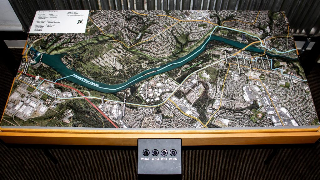
7-foot Tall Model Of Folsom River District To Highlight Development’s Next Steps

In February 2025, Folsom unveiled an interactive scale model as part of its River District Master Plan, aiming to enhance public engagement and awareness. This model, measuring approximately 7 feet tall, 6 feet long, and 2.5 feet wide, was designed to familiarize residents with the development plans along the over six-mile stretch of the American River and Lake Natoma.

The River District Master Plan focuses on several key objectives: increasing public access to the river and lake, expanding recreational opportunities, fostering economic development, ensuring high-quality design, preserving Folsom’s heritage, protecting environmental, cultural, and historical resources, recognizing city gateway opportunities, and integrating both old and new areas of the city.

Rob Ross, a 20-year Folsom resident and member of the River District Organizing Committee, emphasized the importance of enhancing river access and enjoyment for the community. The portable model, equipped with lights and screens, serves as a tool to inform and involve residents in the city’s development plans, ensuring that Folsom maintains its small-town charm amidst growth.

This initiative reflects Folsom’s commitment to thoughtful urban planning and community involvement, aiming to balance development with the preservation of natural and cultural assets.

MORE >>>

Nutria Discovered in San Joaquin Valley; CDFW Seeks to Prevent Further Spread and Infestation

The California Department of Fish and Wildlife (CDFW) has become aware of a population of invasive nutria (Myocastor coypus) reproducing within the San Joaquin Valley. Given the severity of potential impacts and the impacts realized in other infested states, CDFW believes early intervention actions could be successful in eradicating nutria from the area and is asking the public’s help in looking for and reporting nutria sightings in order to determine the extent of the infestation.

To date, nutria have been found in wetlands, rivers, canals and other freshwater habitat in Merced, Fresno and Stanislaus counties. If allowed to establish, nutria will severely impact California’s resources, causing the loss of wetlands, severe soil erosion, damage to agricultural crops and levees and reduced stability of banks, dikes and roadbeds, as they have done in Louisiana, Chesapeake Bay and the Pacific Northwest. Nutria also degrade water quality and contaminate drinking supplies with parasites and diseases transmissible to humans, livestock and pets.

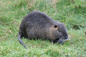
Native to South America, nutria are large, semi-aquatic rodents that reach up to 2.5 feet in body length, 12-inch tail length and 20 pounds in weight. Nutria strongly resemble native beaver and muskrat, but are distinguished by their round, sparsely haired tails and white whiskers (see CDFW’s Nutria Identification Guide). Both nutria and muskrat often have white muzzles, but muskrats have dark whiskers, nearly triangular (laterally compressed) tails and reach a maximum size of five pounds. Beavers have wide, flattened tails and dark whiskers and reach up to 60 pounds.

Female nutria are reproductive by six months of age, breed year-round, and can produce three litters in 13 months. Within approximately one year of reaching reproductive maturity, one female nutria can result in more than 200 offspring, which can disperse as far as 50 miles.

Nutria are destructive, wasteful feeders that destroy up to 10 times the vegetation they consume. Signs of presence typically include cut, emergent vegetation (e.g. cattails and bulrushes), with only the base portions eaten and the stems left floating. Nutria construct burrows with entrances typically below the water line, though changing water levels may reveal openings. Similar to other aquatic mammals, nutria often create runs, or paths in and out of the water or between aquatic sites. Nutria tracks have four visible front toes and, on their hind feet, webbing between four of five toes. Tracks are often accompanied by narrow tail drags.

Since March 30, 2017, more than 20 nutria, including males, pregnant females and juveniles, have been documented within private wetlands near Gustine, duck clubs, the Merced River near Cressey, adjacent to the San Joaquin River near Grayson, south of Dos Palos, the San Luis National Wildlife Refuge, and Salt Slough on the San Joaquin River. The full extent of the infestation is not yet known.

A multiagency Nutria Response Team, which includes representatives from CDFW, the California Departments of Food and Agriculture, Parks and Recreation, and Water Resources, the U.S. Department of Agriculture, the U.S. Fish and Wildlife Service and local county agricultural commissioner offices, has convened with the goal of eradicating nutria from the state. The response team is currently preparing an eradication plan, the first stage of which is determining the full extent of the infestation. Assistance from local landowners and the public throughout the Central Valley, Sacramento-San Joaquin Delta and beyond is critical to successfully delineating the population.

Suspected observations or potential signs of nutria should be photographed and immediately reported to CDFW’s Invasive Species Program online, by e-mail to invasives@wildlife.ca.gov, or by phone at (866) 440-9530. Observations on state or federal lands should be immediately reported to local agency staff at that land. CDFW has a nutria webpage and a downloadable PDF with photos and detailed descriptions of these rodents, their preferred habitat and the environmental threats they present.

It’s a brutal end for these salmon, but it replenishes oceans and feeds families

Thousands of salmon make the grueling journey from the Pacific Ocean up the American River each fall. The spawning run ends for many with a whack on the head at the Nimbus Fish Hatchery, where salmon eggs are gathered and fertilized.

The salmon would normally die a slow death after spawning. But at Nimbus, they’re quickly dispatched in a process viewed annually by hundreds of children and adults through big glass windows at the hatchery in Gold River.

What becomes of the dead salmon is less well known. While the ending isn’t happy for the adult fish, their offspring repopulate the oceans, and tens of thousands of pounds of salmon fillets feed hungry families in northern and central California during the winter months.

More at SacBee.com >>>

Folsom Lake and Lake Natoma had high E. coli readings

Environmental advocates are calling on state officials to notify the public about past tests showing high levels of E. coli in Folsom Lake and Lake Natoma, two of the region’s most popular areas for open water swimming and boating.

But officials responsible for recreational use on the lakes say the test results cited are too old, while the agency that conducted the tests says it has no responsibility for public notices.

The Central Valley Regional Water Quality Control Board in December concluded that the amount of E. coli in the lower American River had exceeded the federal threshold for safe recreational use. The test results didn’t become public until The Sacramento Bee reported them in late August.

The findings were based on water samples taken from 2007 to 2014. Some tests showed E. coli concentrations in Lake Natoma were eight times the level considered safe for recreational use by the U.S. Environmental Protection Agency.

A board report earlier this year found elevated E. coli levels in the lower American River in 2015 and 2016, but did not include samples from Lake Natoma and Folsom Lake, where tens of thousands of people swim, boat and fish every year. The board has limited funds for testing and wanted to focus on areas where higher levels had been found in the past, said Adam Laputz, assistant executive officer at the board. The highest concentrations have been near downtown Sacramento.

E. coli can sicken and even kill people who swim in or drink contaminated water. State and county officials have said they’re not aware of anyone getting sick from the bacteria in the American River.
More at SacBee.com >>>

Nimbus Hatchery Fish Ladder to Open Oct. 9

The Nimbus Hatchery Fish Ladder on the American River will open on Monday, Oct. 9 at 10:45 a.m. The ladder is opening unusually early in the season to accommodate the arrival of returning adult fall-run Chinook salmon that hatched in the Coleman National Fish Hatchery (CNFH) in Battle Creek in 2014. Eggs from fall-run Chinook salmon that stray to Nimbus Hatchery will be returned to CNFH to ensure a healthy population of these fish for commercial, recreational and ecological purposes.

“These fish were born at the height of the drought in 2014,” said Jay Rowan, California Department of Fish and Wildlife (CDFW) North Central Region Senior Environmental Scientist. “They were trucked to the Delta as fry and released near Rio Vista and the San Pablo Bay as part of a massive effort to improve their chances for survival in a year of poor river conditions.”

Returning now as adults, many of these salmon will stray into the American River and not return to their home waters to spawn. The lack of returning fish will make it extremely difficult for the CNFH to reach their goal of producing 12 million fall-run Chinook salmon this fall to release in the waters below Lake Shasta.

CDFW is partnering with the U.S. Fish and Wildlife Service (USFWS), with the support of the Bureau of Reclamation, to collect eggs at Nimbus Fish Hatchery to assist CNFH in meeting its production goals and maintaining a stable salmon population on Battle Creek and the upper Sacramento River.

When the salmon reach Nimbus Hatchery, staff will separate out the fish that have had their adipose fin removed, indicating that they carry a tiny coded wire tag that records their hatchery of origin. Fish identified as being of CNFH origin will be spawned with one another, and their fertilized eggs returned to CNFH. Fish that have not had their adipose fin removed will be spawned and their eggs held until it is determined if they will be needed to meet CNFH production goals.  Fish that are not yet ready to spawn will have a colored tag attached to their dorsal fin and will be returned to the American River, where they will be available to anglers until they either spawn naturally or climb the ladder again and are spawned at the hatchery to meet the Nimbus Fish Hatchery egg collection goals. While anglers are able to catch and keep fish marked with these tags, the tags have no monetary value and do not need to be returned to CDFW.

From >>> cdfgnews.wordpress.com

Lower American River contains unsafe levels of E. coli. Are homeless camps to blame?

Levels of E. coli bacteria found in the lower American River exceed the federal threshold for safe recreational use, in part due to human waste from homeless camps, state regulators say.

The Central Valley Regional Water Quality Control Board has proposed adding the bacteria to a list of pollutants that make the lower American River a federally designated impaired water body. A state board is expected to sign off on the decision later this year and ask for final approval from the U.S. Environmental Protection Agency.

E. coli can sicken and even kill people who swim in or drink contaminated water. State regulators say they’re not aware of anyone who has been sickened by E. coli in the the lower American River, but nearly a decade of test data indicate the risk of exposure.

“It should give people some discomfort about using the water – it’s not good,” said Ron Stork of Friends of the River.

A report summarizing test results from 2007 to 2014 found average levels of E. coli at three sites that were higher than the EPA standard, “beyond which the water body is not recommended for recreation.” The three sites are in the westernmost section of the American River Parkway, near downtown Sacramento, where the highest concentration of homeless camps are set up.

Seventeen of the 25 test sites had at least one recording in excess of the federal threshold, according to the “Safe-to-Swim Assessment.”

Thousands of people use the lower American River each year, from the boaters who launch at Discovery Park, to the swimmers who enjoy the beach at Sutter’s Landing Regional Park, to the triathletes who participate in Eppie’s Great Race.

“My concern is that it could make me sick,” said Alex McDonald, who was sitting in the water with his wife at Sutter’s Landing last week. “I would like to know more.”

More at SacBee.com >>>