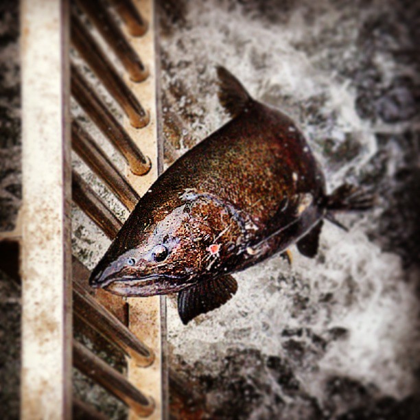
Placer County Water Agency: Water Forum Transfer Partnership

The Placer County Water Agency (PCWA) Board of Directors on Thursday (Aug. 15) approved a memorandum of understanding (MOU) with the East Bay Municipal Utility District (EBMUD) to move forward on development of a potential long-term water transfer that meets their mutual water supply reliability interests and improves the ecosystem of the lower American River.

The potential transfer of water from PCWA’s Middle Fork American River Project would further affirm PCWA’s Water Forum stewardship commitments to the lower American River and likewise assist EBMUD in strengthening its water supply reliability needs.

Under the PCWA board action, staff will develop details of the transfer, including duration and financial terms, for future board consideration.

PCWA, as one of many local water purveyors in the American River basin, is a signatory of the Water Forum agreement.  The agreement outlines a multipart plan to increase diversions from the American River to meet increasing future demands locally while at the same time implementing dry year actions to protect the lower American River’s aquatic resources, including Chinook salmon and the federally-threatened Central Valley steelhead.

More at RocklinToday.com >>>

American Fire Burning 13,730 Acres

Located in Tahoe National Forest outside of Foresthill, the Americna Fire continues to burn in steep and hazardous terrain as well as timber fuels that have not burned in several decades. Consumption of heavy fuels continues to contribute to the heavy smoke in the surrrounding areas.

An emergency closure order is in place for portions of National Forest System lands within and adjacent to the American Fire.

A map and description of the closed area can be obtained at Tahoe National Forest offices as well as online at http://www.fs.usda.gov/tahoe

American Fire: 13,730 acres burning / 49% containment.
1,851 Firefighting Personnel
10,000 Acres ~ 15 Square Miles

More at RocklinToday.com >>>

7 Acres Burn On Parkway Near Site Of Earlier Fires

A fast-moving grass fire on the American River Parkway in Rancho Cordova has been contained after burning about 7 acres.

Capt. Christopher Quinn of the Sacramento Metropolitan Fire District said the fire was reported about 3 p.m. near Friday the El Manto access off Ambassador Drive. No homes were threatened.

He said the fire was in the same general area as three other grass fires believed to have been deliberately set along the parkway in recent weeks.

More at SacBee.com >>>

Sierra Foothills Wildfire Leads To Forest Closure

The U.S. Forest Service has ordered an emergency closure for portions of the Tahoe National Forest near a remote Northern California wildfire that has burned more than 11 square miles of steep, wooded terrain.

Heavy smoke from the fire 10 miles northeast of Foresthill at times has blanketed portions of the Sierra Nevada foothills, the Sacramento Valley and stretched to Lake Tahoe.

An air quality warning has been issued for Placer County, northeast of Sacramento. The Forest Service says smoky conditions might last through the weekend.

The fire is burning along a tributary of the Middle Fork of the American River and is not threatening homes.

More at WRAL.com >>>

Bike Trail Exits Along American River Pkwy. Will Be Closed, Check Out Detours

Do you enter or exit the American River Parkway at Watt Avenue and American River Drive? Access ramps to the American River Parkway on the north bank of the Watt Avenue Bridge will be closed day and night beginning August 17 and will continue for five weeks until Saturday, September 21st. The Jedediah Smith Memorial Trail/Bike Trail will remain open for through traffic under the bridge. The US Army Corps of Engineers are strengthening the levees at this location and the trail accesses are being closed for safety reasons.

These north side ramp closures will also impact access for those wishing to cross the Watt Avenue Bridge from the south side.  The pedestrian/bicycle bridge lanes will be blocked off preventing access to the bike trail and surface streets north of the river.

Detour access points are available both upstream and downstream from Watt Avenue and are located at the Kadema Drive and Estates Drive accesses.  View the detour maps.

From SacCounty.net

Guy West Bridge Is A Neglected Icon

Drive down Fair Oaks Boulevard and across the bridge over the American River, look south and you will see what appears to be a miniature version of the Golden Gate Bridge, which is precisely what was intended when it was built in 1966.

It connects California State University’s Sacramento campus with University Avenue and the Campus Commons neighborhood, and is heavily used by students at Sacramento State, as well as nearby residents who like to stroll over to the campus for lunch or to attend an event.

The Guy West Bridge, for pedestrians only, was named in honor of the founding president of what was then Sacramento State College.

But it has fallen into disrepair and is only a shadow of its former self, its once bright red-orange color faded and rusty, showing its age and rapidly becoming more of an eyesore than the icon it was meant to be.

More at SacBee.com >>>

Sacramento’s River District On The Cusp Of Big Growth

More than a century ago, what is now known as Sacramento’s River District was known for flooding.

In the 1930s, it was known for canning. Later, it became a gritty mix of working factories and derelict buildings, close to downtown but isolated and often forgotten.

But now, the 830-acre district north of the historic railyard and Sacramento’s downtown core is seeing an influx of residential, office and commercial land-use projects.

In recent years, a new road and a light-rail extension have provided better connection to the rest of the city. More than $450 million has been invested in the district through public and private projects, bringing along more than 1,000 new jobs.

Patty Kleinknecht, executive director of the River District nonprofit association representing business and property owners, said the area’s transformation has been the result of a “genuine partnership” among businesses, developers, transportation officials, government leaders and urban planners.

“Particularly over the last five years, we’ve seen smart growth, mixed-use development close to the business center of our region, with easy access to a lot of different forms of transportation,” Kleinknecht said.

Long-established companies still dot the area, including the venerable Blue Diamond Growers cooperative, dating back to 1910. But recent arrivals have been numerous, adding a modern vibe to the district.

They include the California Lottery headquarters building, an imposing structure with curving exterior lines, hundreds of square feet of blue glass and aluminum, and LED lighting.

Inside the building, food truck operator Krush Burger opened a brick-and-mortar restaurant late last year.

The Party Concierge, the special event services/amenities business whose facilities burned in an August 2012 fire, has reopened nearby in a 42,000-square-foot building at 601 N. 10th St. The significantly upgraded building features modern architectural touches inside and out, including ceiling-high windows letting in natural light.

Last year, a new light-rail station opened at Seventh Street and Richards Boulevard. The open-air brick-and-metal structure, topped by a Township 9 sign that lights up at night, has the look of a train stop in a European capital.

The station borders the 65-acre Township 9 mixed-use development site, where construction continues on the Cannery Place Apartments, a 180-unit, $40 million development that also will include retail. Construction is expected to be completed in October next year.

Steve Goodwin, president of the River District board of directors and Township 9, uses the word “momentum” repeatedly when describing the area.

“That’s momentum … from more employment, more businesses, more services and more investment,” he said.

Goodwin remembers a different time, when the decades-old Tri-Valley Growers cannery was being readied for the wrecking ball, clearing space for Township 9 work.

“We’ve been here for about 14 years now, and back then, well, it was kind of a dump. It was considerably more blighted,” he said. “There was a lot yet to be done. It was really in its infancy in terms of its redevelopment.”

Numerous projects, including a widening of Richards Boulevard, altered the district, but Goodwin points to the Seventh Street extension project, completed in March 2004, as the key milestone.

More at SacBee.com >>>

American River Flow Changes This Week For Fish Weir Installation

Flows will change in the American River this week while federal officials install a fish weir below Nimbus Dam to prepare for the fall salmon migration.

Overnight Wednesday, the U.S. Bureau of Reclamation planned to drop American River flows from 2,500 cubic feet per second to 1,000, then return to 2,500 during the day. This is planned so crews can do maintenance on the weir structure.

Then on Friday starting at 1 a.m., flows will be dropped again to 1,000 cfs to install the weir, and increased back to 2,500 cfs by afternoon.

These actions will change the river elevation by about 14 inches, as measured in Fair Oaks. People recreating and traveling along the river are advised to use caution near the water’s edge.

The weir is installed across the river annually to guide spawning fall-run Chinoook salmon into the Nimbus Hatchery fish ladder.

More at SacBee.com >>>


Placer Land Trust, Emigrant Trails Greenway Trust, To Protect Another 160 Acres On The North Fork American River

Placer Land Trust has teamed with the Emigrant Trails Greenway Trust to acquire another 160 acres of land on the North Fork American River at Gillis Hill, guaranteeing a five-mile stretch of the river stays forever wild and scenic.

“This is the only private parcel on the river for miles in either direction,” said Placer Land Trust’s Executive Director Jeff Darlington. “Protecting this property from development ensures that a five-mile stretch – from above the Colfax Iowa Hill Bridge downstream past Indian Creek and Shirttail Creek all the way to Yankee Jim’s Bridge – will remain wild and scenic, forever.”

The “Mergen North Fork Preserve” borders existing public land within the Auburn State Recreation Area along stretch of the North Fork American River containing Staircase Rapids, well known by rafters, kayakers, and other river enthusiasts. Emigrant Trails Greenway Trust (ETGT), a private philanthropic foundation, partnered with Placer Land Trust to protect this property from residential development within the canyon.

“Protecting this critical portion of the watershed strengthens national wild and scenic values upstream, and water quality downstream,” said Patty Schifferle, ETGT Trustee. “This purchase connects substantial investments along the North Fork American River where habitat corridors and scenic corridors are critical to our community.”

ETGT funding was augmented by funds from Placer Land Trust’s wetlands mitigation account (funded by Placer County Water Agency) as well as support from over 700 land trust members. Placer Land Trust purchased the property from Paul & Joy Mergen for $175,000.

The North Fork American River has long been an area of special interest and continues to be a priority for Placer Land Trust, due in large part to its popularity as a recreation destination.

More at YubaNet.com >>>

Guidelines Issued On Eating Fish From California Lakes, Reservoirs

A state environmental health agency has issued its first-ever set of statewide guidelines for eating fish from California’s lakes and reservoirs, including many in Northern California and the Sierra.

The California Office of Environmental Health Hazard Assessment’s advisories are meant to help the public decide what fish can be safely eaten – especially from hundreds of lakes and for reservoirs that have not had fish consumption advisories established.

Most bodies of water with fish-eating advisories – because fish sampled there have high levels of methyl mercury – are found in Northern California and the Gold Rush country, as well as in the Sacramento-San Joaquin Delta.

“Prior to these new guidelines, hundreds of lakes and reservoirs in the Sierra had no fish consumption warnings – which led the public to believe that the fish from those locations were safe to eat,” said Amber Taxiera, community outreach coordinator with the Sierra Fund. “This is a big step forward for OEHHA.”

The new advisory recommends that women between the ages of 18 and 45 and children under 18 should avoid eating bass, carp and brown trout larger than 16 inches because of a risk of methyl mercury exposure, which has been shown to damage the brain and nervous system.

Some species of fish, including bullhead, catfish and bluegill, are acceptable for consumption at one serving a week. Species that are safe to eat include wild-caught rainbow trout and small brown trout. The advisory and guidelines stem from OEHHA’s evaluation of 272 lakes and reservoirs, and 2,600 fish samples.

The advisory combined mercury data from fish in California lakes that currently do not have advisories and compared those mercury levels to acceptable human exposure levels.

In the Sacramento region, at Folsom Lake and Lake Natoma, the advisory recommends following the new guidelines if the fish caught are not covered by already set location-specific guidelines.

More at ModBee.com >>>