Category Archives: News from Other Watersheds

News from other watersheds.

Nimbus Hatchery Fish Ladder to Open Oct. 9

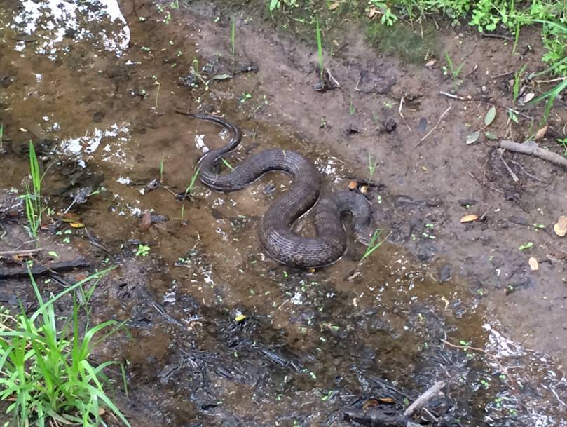
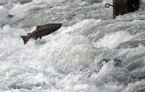
The Nimbus Hatchery Fish Ladder on the American River will open on Monday, Oct. 9 at 10:45 a.m. The ladder is opening unusually early in the season to accommodate the arrival of returning adult fall-run Chinook salmon that hatched in the Coleman National Fish Hatchery (CNFH) in Battle Creek in 2014. Eggs from fall-run Chinook salmon that stray to Nimbus Hatchery will be returned to CNFH to ensure a healthy population of these fish for commercial, recreational and ecological purposes.

“These fish were born at the height of the drought in 2014,” said Jay Rowan, California Department of Fish and Wildlife (CDFW) North Central Region Senior Environmental Scientist. “They were trucked to the Delta as fry and released near Rio Vista and the San Pablo Bay as part of a massive effort to improve their chances for survival in a year of poor river conditions.”

Returning now as adults, many of these salmon will stray into the American River and not return to their home waters to spawn. The lack of returning fish will make it extremely difficult for the CNFH to reach their goal of producing 12 million fall-run Chinook salmon this fall to release in the waters below Lake Shasta.

CDFW is partnering with the U.S. Fish and Wildlife Service (USFWS), with the support of the Bureau of Reclamation, to collect eggs at Nimbus Fish Hatchery to assist CNFH in meeting its production goals and maintaining a stable salmon population on Battle Creek and the upper Sacramento River.

When the salmon reach Nimbus Hatchery, staff will separate out the fish that have had their adipose fin removed, indicating that they carry a tiny coded wire tag that records their hatchery of origin. Fish identified as being of CNFH origin will be spawned with one another, and their fertilized eggs returned to CNFH. Fish that have not had their adipose fin removed will be spawned and their eggs held until it is determined if they will be needed to meet CNFH production goals.  Fish that are not yet ready to spawn will have a colored tag attached to their dorsal fin and will be returned to the American River, where they will be available to anglers until they either spawn naturally or climb the ladder again and are spawned at the hatchery to meet the Nimbus Fish Hatchery egg collection goals. While anglers are able to catch and keep fish marked with these tags, the tags have no monetary value and do not need to be returned to CDFW.

From >>> cdfgnews.wordpress.com

Snow survey reveals CA water content at 185% of average

The Sierra snowpack survey conducted Wednesday revealed that the northern Sierra water content is well above average for this time of the year and bodes well for runoff later in the year.

Numbers manually taken by water officials at the Phillips Station in El Dorado County revealed 43.4 inches of water content, which is 179 percent of the long-term average for March 1, and a snow-depth of 112.7 inches.

The water content did not break the record of 56.4 inches for that station, but Frank Gehrke, of the California Department of Water Resources, said it is “a pretty phenomenal snowpack.”

“It bodes very well for runoff much longer than we have had in the past four or five years,” Gehrke said. “It’s a very, very good indicator of good surface water supplies as we head into spring and summer.

As of March 1:

  • The northern Sierra is 159 percent of average.
  • The central Sierra is 190 percent of average.
  • The southern Sierra is 201 percent of average.

The central and southern regions are tracking “very close” to 1983, which is when the maximum snowpack was recorded statewide.

More at KCRA.com >>>

California high court upholds ban on dredges to extract gold

California’s ban on the use of suction dredges to extract gold from rivers is legal and not overridden by a 19th century federal law that allows mining on federal land, the California Supreme Court ruled Monday.

The court’s unanimous decision was a victory for environmentalists and a blow to miners, who argued that the ban essentially stopped gold mining because doing it by hand is labor intensive and makes the enterprise unprofitable.

Environmentalists say suction dredge mining risks killing fish and stirring up toxic mercury.

The high court’s ruling came in an appeal of a criminal case in which miner Brandon Rinehart was convicted of a misdemeanor for suction dredge mining without a permit in 2012 and sentenced to three years of probation.

Associate Justice Kathryn Werdegar, writing for the court, said the federal Mining Law of 1872 did not guarantee a right to mine free from regulation.

Instead, its goal was to protect miners’ property rights involving the federal land to which they laid claim, she said.

“The mining laws were neither a guarantee that mining would prove feasible nor a grant of immunity against local regulation, but simply an assurance that the ultimate original landowner, the United States, would not interfere by asserting its own property rights,” she wrote.

Rinehart’s attorney, James Buchal, said the high court showed a “casual disregard” for federal law.

He said Rinehart would likely ask the court to review its ruling or appeal to the U.S. Supreme Court.

Suction dredges are powerful underwater vacuums that suck up rocks, gravel and sand from riverbeds to filter out gold.

More at USNews.com >>>

Gold Miners Rescued via Helicopter near Lake Tahoe

Two gold miners were rescued via helicopter from the rugged wilderness near Lake Tahoe Wednesday, according to the California Highway Patrol.

Three friends had gone panning for gold Tuesday in the Sawtooth Ridge area, near the north fork of the American River, the Placer County Sheriff’s Office said. One man returned to camp early, leaving the other two at the river.

The next day, investigators say the man was unable to contact his friends, Denny McCloud and Denny Jr.

More at Fox40.com >>>

Cave Valley near Auburn drawing climbers 7 days a week

Surf Tower, Tilting Vertex and Wreckage Wall may sound like roller coaster rides at a favorite amusement park, but these routes along the limestone cliffs at Cave Valley climbing area provide a different kind of adrenaline rush for local enthusiasts.

Cave Valley reopened to allow daily access to climbers last year, but a few climbing routes are off-limits this summer as the California Department of Parks and Recreation works to protect a nearby aerie, or nest, of peregrine falcons. The partial closure is an experiment to strike a balance between providing recreational activities to the rock climbing community and fostering local wildlife.

“It’s exciting and interesting that they were able to find a compromise between industry, recreation and the environment,” said Eric Peach, board member of Protect American River Canyons.

Jason Flesher, Sierra marketing manager for REI, an outdoor company that contracts with the Parks Department to teach classes in the canyon, said the partial closure has disrupted only one of REI’s classes so far. That class was moved to another location and subsequently was rained out.

“We were worried the whole area would be closed,” Flesher said “We’re glad it’s only a partial closure. REI is also interested in (protecting) the environment.”

The closure doesn’t seem to have slowed down activity in that area of the canyon. It was 90 degrees on a recent Sunday, but the quarry was full of climbers, coiled ropes and clinking carabiners. One experienced climber scaling the cliff face that day was Gordon Ainsleigh, founder of the Western States Endurance Run. Ainsleigh rides his bike from the trailhead to the climbing site a couple of times a week in preparation for a Yosemite climb later this summer.

“The falcons are usually noisy in the morning,” Ainsleigh said. “That’s when they’re hungry.”

More at AuburnJournal.com >>>

Risk rises for Lyme disease in summer

As the weather warms, many look to plan fun outdoor activities, but increased time outside also increases the risk for encounters with ticks, which can be carriers of Lyme disease.

Lyme disease is transmitted to humans through the bite of infected blacklegged ticks, known as deer ticks, frequently encountered in tall grasses and wooded areas.

According to the Centers for Disease Control and Prevention, an estimated 300,000 infections occur each year, of which only 30,000 are reported to CDC by state health departments.

Lyme is a bacterial illness that is spread by tick bites. Typical symptoms include fever, headache, fatigue and a characteristic skin rash called erythema migrans. If left untreated, infection can spread to joints, the heart and the nervous system, officials said.

There are several tactics that can prevent tick bites and reduce the risk of tick borne disease, according to the CDC.

More at FolsomTelegraph.com >>>

California Nerodia Watch

Nerodia Sipedon
Let’s hope we don’t get more Nerodia in the American River watersheds! Please report any sightings.

Nerodia Watch enlists citizen scientists to report sightings of Nerodia watersnakes in California. Nerodia threaten California’s native fish and wildlife species through predation and competition for resources. Their fast rate of population growth, ability to disperse overland to new habitat, and close proximity to special status species causes great concern for California’s native fish and wildlife species. This campaign is intended to monitor for the spread of existing populations, prevent the establishment of new populations, and facilitate rapid response management efforts to control or eradicate Nerodia watersnakes in California.

Currently, N. sipedon is established in Roseville (Placer County) and N. fasciata pictiventris is established in Folsom (Sacramento County) and Machado Lake (Los Angeles County). Areas that should be targeted for surveying include most types of permanent freshwater habitats, such as ponds, wetlands, canals, and slow-moving streams and rivers. Specific locations of interest include in and around Roseville, Folsom, the lower American River, the Sacramento River watershed west/southwest of Sacramento, Stone Lakes National Wildlife Refuge, Little Potato Slough, French Camp, the Sacramento-San Joaquin Delta, and Los Angeles County.

For more information on Nerodia watersnakes in California, visit CDFW Invasive Species Program – Species profiles, The California Nerodia website, the Stop the Spread of Non-Native Water Snakes in California Facebook group, and CaliforniaHerps.com.

In 2008, all Nerodia watersnake species were added to the California Department of Fish and Wildlife’s list of restricted live animals, making it illegal to possess, transport, or import them into the state without a restricted species permit from the Department of Fish and Wildlife.

A Short Run for Some California Whitewater Rivers This Season

Justin Butchert drops bags of ice into huge coolers and lifts them onto his pickup truck.

“This is our only form of refrigeration up there,” says Butchert, owner of Kings River Expeditions.

He’s referring to his company’s base camp on the Kings River, east of Fresno in the Sierra Nevada. The outfit has run overnight trips, complete with cookouts and goofy campfire skits, for more than 30 years.

But this is the first time in 25 years he’s packed the food.

“You know I just do everything now,” he says. “We used to have a full staff doing this and we don’t have that anymore.”

He has the same number of employees, but they’re working fewer hours. In the best of years, his company stays open until Sept. 1 and guides about 6,000 folks down miles of roaring rapids.

More at KQED.com >>>

New Study Identifies Roadkill Hotspots In Sacramento Region

A detailed inventory of animals killed on area roads has identified 22 areas in the Sacramento region where drivers are most likely to encounter wildlife crossing a roadway.

The release of the report on roadkill hotspots is considered a crucial tool to help drivers avoid possible fatal accidents and is being seen as a guide for scientists and agencies who seek to protect endangered species and other wildlife that cross roads and freeways.

The report, authored by Fraser Shilling of the UC Davis Road Ecology Center, culled volunteer observer reports of such incidents from 2009-2014 to establish where collisions between cars and animals were occurring.

The region’s hotspots include several points along Interstate 80 and and I-5. One is a stretch of I-80 over the Yolo Bypass where bird strikes are common.

Another is a stretch of I-80 where the freeway and Highway 49 converge in Auburn near the American River, “where there is no opportunity to go under the highway,” said Shilling, “so wildlife will go over it.”

Between April 1, 2010, and March 30, 2013, there were 365 crashes involving wildlife, livestock and other animals in the state Department of Transportation’s District 3, said Caltrans spokesman Mark Dinger. The district includes Sacramento and 11 Northern California counties, covering I-80 from Davis to the California/Nevada state line and I-5 from north of Stockton to north of Orland.

Statewide, Caltrans inventoried 3,126 reported collisions involving animals, Dinger said.

One human fatality in Sacramento County has been attributed to a wildlife collision since 2006.

Shilling said the roadkill report was compiled with the help of 1,100 volunteer observers throughout the state, including himself. The survey is the most extensive database documenting animal and vehicle collisions in California.

“Last year it seems like there has been an increase in rate of deer getting hit,” said Shilling. He said observation of deer hit by autos more than doubled last year.

He speculates that the drought may have something to do with it.

“They’re moving around more,” said Shilling. “They get moisture from vegetation, and they were probably having a hard time getting enough to eat.”

Despite the increase in deer mortality, roadkill observations overall have gone down slightly this year, said Shilling.

He believes the decline is not reflective of animals avoiding roadways. Instead he believes that roadways are decreasing wildlife populations, resulting in fewer roadkill observations.

The roadway hotspot with the most animal deaths is State Route 70 near Portola Valley. That stretch of road had 343 animals from 25 species killed in the roadway.

Shilling said that the numbers are deceptive, as the large majority of encounters between cars and animals go unreported.

The actual mortality on freeways and highways and streets is “much, much higher than this report represents,” said Doug Long, one the most prolific observers contributing to the database, with more than 3,000 roadkill observations logged since the effort began six years ago. Long is professor of ecology and biology at St. Mary’s College.

During a drive from Riverside to Oakland, Long used a special application on his phone to log 80 different species of roadkill he encountered on the drive. These include a wide variety of species – from snakes to birds, he said.

“You have to remember that the data points in the report have been collected by people (who) represent a very small fraction of all the people in California,” said Long.

Long said it is likely that 99 percent of encounters between wildlife and vehicles are never recorded.

More at SacBee.com >>>

Spring To Arrive Rain-Free In Sacramento And North State, Much Like Winter

The official arrival of spring today brings with it the realization that Sacramento and the Sierra Nevada have again been abnormally dry for the fourth straight winter.

The rainy season began in the fall with hope that the drought would be broken, but that was not to be.

With the exception of one big “Pineapple Express” in December and a good rain in February, Sacramento has been dry – and, lately, warm.

On Thursday, Sacramento set a record when the high temperature reached 81 degrees at Executive Airport, topping the previous mark of 80 degrees set in 2004, according to the National Weather Service.

The lack of rain was especially stark in usually soggy January when just 0.01 of an inch was recorded in Sacramento.

The winter also did not deliver a great deal of snow to the Sierra Nevada. California’s water supplies are reliant on mountain snowpack that melts in the spring and fills reservoirs for summer use in cities and on farms.

The most recent snowpack survey showed that statewide the mountains have just 13 percent of the snowpack normal for this time of year.

“Generally our snowpack accounts for about a third of our state water supply,” said Brooke Bingaman, weather service meteorologist. “Not all of the 13 percent snowpack will end up in the reservoirs, some of it will soak into the ground. So the level our reservoirs are at now is essentially what we will have for the rest of the summer.”

The culprit behind the snowfall shortfall is a familiar meteorological villain – a high-pressure ridge that has shunted snowy storms to the north, Bingaman said.

In addition, the northern part of the state usually gets five to seven atmospheric rivers, large storms that can drop several inches of rain. This year, Sacramento got two such storms.

One hit in December, a month when 7.63 inches fell and another in February, when 2.28 inches of rain were recorded.

“Since Oct. 1, we have had 11.73 inches,” Bingaman said. “Normally we should have had 16.64. So we are at 70 percent of normal right now.”

Bingaman said Folsom Lake is 59 percent full, but it won’t get the usual snowmelt from the American River.

“December, January, February and March are typically our wettest months of the year,” she said. “Really, December was the only month that was really wet.”

More at SacBee.com >>>